
Jonesboro, AR – (JonesboroRightNow.com) – April 5, 2025 – There have been severe weather warnings issued for Jonesboro on five of the last seven days. Residents in Bay, Lake City and Monette were still cleaning up tornado damage from Wednesday night when tornado, severe thunderstorm and flash flood warnings were issued yet again midday Saturday.
By mid-afternoon Saturday a frontal zone that has been the focal point for the severe weather this week had pushed South and East of Craighead County and had put Jonesboro in cooler and more stable air meaning the threat for severe thunderstorms and tornadoes had moved away from Jonesboro.
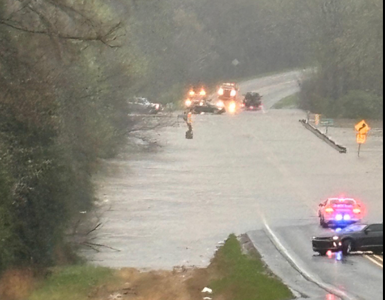
The focus now turns to flooding rains. The automated weather station (AWOS) at the Jonesboro Municipal Airport has recorded 7.88 inches of rain since Wednesday (as of 3pm Saturday). Much higher rainfall amounts have been reported elsewhere across Arkansas and South Missouri. The heavy rain has caused rivers and streams to rise resulting in floods and closed roads.
Flash flooding was reported across Jonesboro early Saturday afternoon as heavy rains moved through. The E911 Dispatch received several calls for help from motorists whose vehicles had become stalled in high water. At least one call came from a vehicle in a ditch. The City of Jonesboro Street Department responded to trees down on Mt. Carmel Road.

Bono Fire Department, Craighead County Sheriff’s Department and Bono Police Department were working on a water rescue on County Road 328 mid-afternoon Saturday.
IDriveArkansas reported numerous road closures and detours due to high water Saturday afternoon.
4.53 miles of US Highway 63 is closed from Imboden to Ravenden due to water over the road.
1.51 miles of US Highway 63 through Downtown Hardy is closed due to high water — traffic on the US Highway 63 Bypass was able to navigate around Downtown Hardy as of 3pm Saturday afternoon.
US Highway 49 is closed at Greenway in Clay County due to high water.
The city of Rector in Clay County had been isolated due to closed roads earlier Saturday. By Saturday afternoons roads North toward Corning and South toward Marmaduke had reopened.
Travelers are urged to check your route on IDriveArkansas prior to departing to make sure the roads and highways on your route are open, especially roads that are typically affected by flooding rains.
Heavy rains were expected to continue across Arkansas and Southern Missouri into Saturday night before the storm system finally pushed to the East and out of the area. A Flash Flood Watch remains in effect until Sunday morning. Even though the rain is expected to end, river flooding will be an issue in the days to come as the historic rainfall totals lead to heavy drain off.