

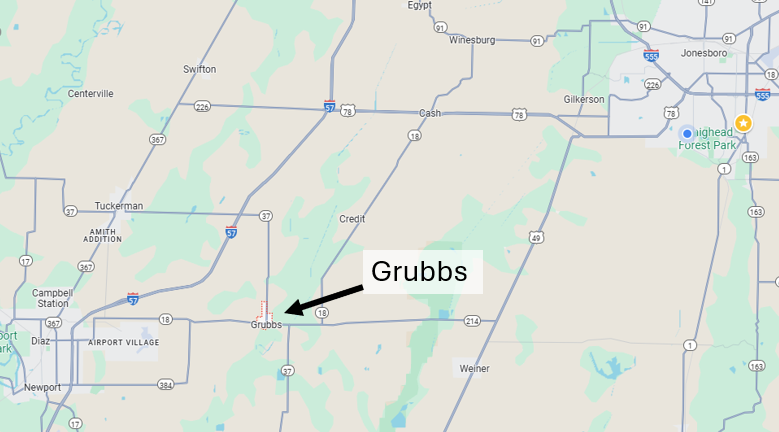
Grubbs, AR – (JonesboroRightNow.com) – June 1, 2025 – “We all try to remain positive, but we have been dealing with flooding daily since January of this year!” The words of a frustrated Grubbs Mayor Candace Miller as she continues to lead the effort to keep floodwater from the nearby Cache River from flooding her town, population 304, in Eastern Jackson County just 25 miles Southwest of Jonesboro.
Flooding along the Cache River has been a persistent problem rooted in both natural geography and human-altered hydrology. Flat terrain and poor drainage contribute to the flooding. The land in the Lower Cache River Basin, including the area round Grubbs, is extremely flat. Water from heavy rains or upstream tributaries has nowhere to go quickly, so it spreads out, especially when the river rises.
Parts of the Cache River were channelized (straightened and deepened) in the early 1900s-1950s to promote agricultural drainage. In addition, massive wetlands and bottomland hardwood forests that absorbed floodwaters were cleared for agriculture. While this helped farms upstream, it increased water flow velocity and reduced natural storage, pushing water faster downstream — toward areas like Grubbs.
In the 1980s-90s the U.S. Fish and Wildlife Service and Army Corps of Engineers began to realize the environmental cost of channelization. Some restoration efforts started — notably the creation of the Cache River National Wildlife Refuge — but the damage to natural flood control was already done. Grubbs, being downstream and near the confluence of several drainage systems, continues to bear the brunt of overflow events like 2025.
Backwater from the White River is also a problem. The Cache flows into the White River, and when the White is high (from heavy regional rains or Mississippi River backup), it causes a backwater effect, preventing the Cache from draining. This is especially problematic in the spring and early summer.
Levees or drainage ditches in the area designed to protect towns like Grubbs are not consistently maintained or adequate for current flooding conditions. “We’ve had 5 major breaks in the levee and several minor ones,” Miller said. “Over time they have become larger. I am told that one of the major breaks has now grown to at least 80 feet.”
Last week Miller led an effort to build a second, smaller levee wall to help keep the water out of her town. On Wednesday the river reached 2011 flood levels and was still rising. When the day was over, Miller said she needed to thank several people for the effort: Breaking Bonds, Michael Lewellyn, Lonnie Mullins, Red (Riceland), Chad Sutherland, David Wood, Michael Brownfield, Chris Clark and road crew and Jackson County Judge Jeff Phillips.
Miller says the flood battle they are fighting costs money. She admits there isn’t an easy fix. “This battle with the river is costing our town, farmers, and neighbors an insane amount of money that we did not have,” Miller says. “This year has been like no other, and the monster continues to grow and threaten us!” She said if the Corps can’t fix the problem, she suggested buying the land on the east side of town and making a new route for the river. An idea that comes with a big price tag.
As of Sunday, Miller said Highway 37 from Grubbs North to Tuckerman was open, and Highway 18 from Grubbs West to Newport is open. Highway 18 is still closed on the East side over the Cache River.
“This is ridiculous that our entire town, our friends, and neighbors have to live this way.”