
Update 1:10pm: The forecast remains unchanged. Conditions are coming together that favor the development of severe thunderstorms and long-track tornadoes across Northeast Arkansas.
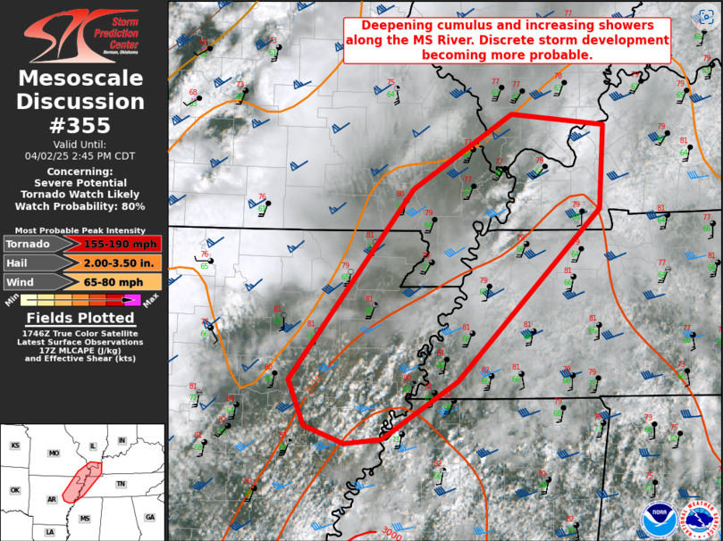
The Severe Storms Forecast Center issued a statement at 1:00pm suggesting that conditions across northeast Arkansas, the Missouri Bootheel, West Tennessee and Western Kentucky were becoming unstable and favor the development of discreet supercell thunderstorms over the next couple of hours. The statement suggested an 80% chance that a Tornado Watch will be issued for this area. So far, no thunderstorms have developed across this area. However, IF the storms form, they could RAPIDLY intensify, become severe, rotate and produce a dangerous tornado. In this scenario the warning for such a storm could be short.
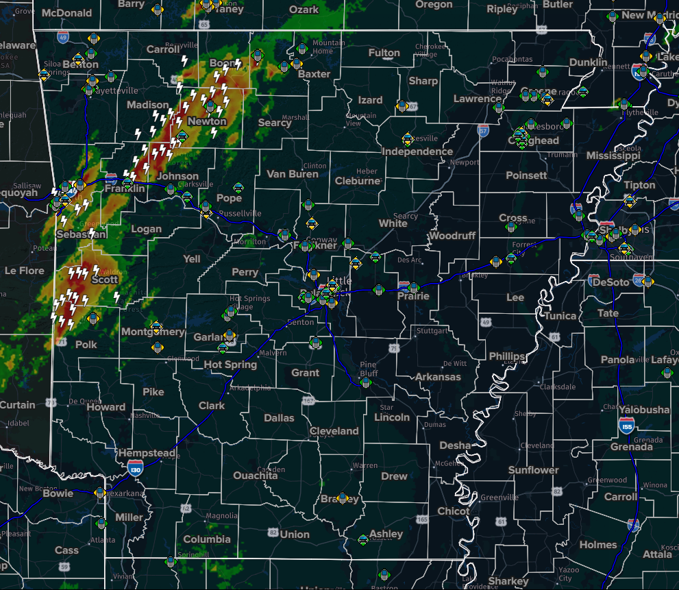
As of 1:00pm, the cold front that is the focal point for this severe weather event had entered Northwest Arkansas. The front had passed through the Fayetteville area and was moving slowly to the East. A line of thunderstorms, some severe, have developed along and just ahead of this cold front, as expected. This line of storms, some of which could be severe, is expected to move through Northeast Arkansas between 5-7pm. These thunderstorms could potentially pack damaging winds, large hail and heavy rain in addition to the threat of a tornado.
The present strongest concern is the possibility of discreet supercell thunderstorms forming out AHEAD of this line.
Stay tuned to your sources for severe weather information. At the Jonesboro Media Group radio stations 104.9 The Fox, 100.5 The Eagle and Mix 106.3 will provide continuing severe weather coverage should it develop. The K8 Storm Team will also provide coverage. Weather information is also available on NOAA Weather Radio, broadcasting in the Jonesboro area on 162.55mhz.
Earlier:
Jonesboro, AR – (JonesboroRightNow.com) – April 1, 2025 – Forecasters are warning Mid-South residents to prepare for several rounds of severe weather and what is being calling “generational rains” in the coming days.
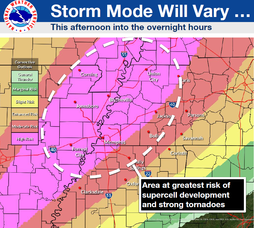
Wednesday afternoon and evening will see an especially high risk for severe thunderstorms and possible tornadoes. Storms are forecast to begin developing mid-afternoon with the timing for the most intense storms estimated between 5 and 9pm. Jonesboro and Craighead County is in an extreme (level 5 out of 5) risk area for intense storms and tornadoes.
There are also risks for additional severe thunderstorms on Thursday and Friday afternoons although the risk appears to be lower than the risk on Wednesday.
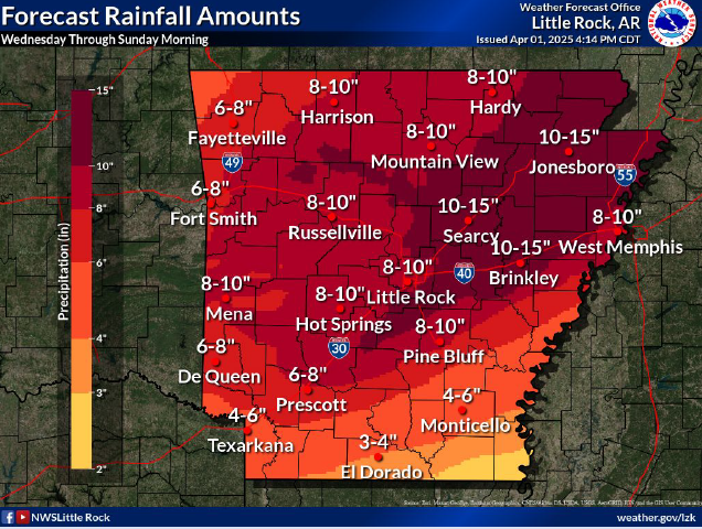
In addition to the threat of severe thunderstorms and tornadoes, forecasters believe there could be several rounds of heavy rain between Wednesday and Sunday that could total as much as 12 inches. A very uncommon “particularly dangerous situation” flood watch has been issued for the entire area because of the expected heavy rainfall.
Residents should review their family plans for severe weather and tornadoes. In addition, residents should consider the impact of flooding rains and take whatever precautions are possible to protect families and property.