

Update Saturday 6:30 a.m. (by Trey Stafford):
The severe weather forecast for Sunday has not changed. A widespread damaging wind event with some tornado threat is likely late Sunday afternoon through Sunday night from northeast Texas to southwest Lower Michigan. The greatest wind damage threat appears to be from northeast Arkansas/western Tennessee to southern Indiana during the evening and overnight hours.
Following the severe weather, the “bottom is going to fall out” of the temperature. Highs in the 70s on Sunday will fall into the 20s by Monday morning. Monday temperatures will not reach higher than the 30s. Jonesboro Right Now and the Jonesboro Media Group radio stations will be watching and reporting on the weather closely Sunday.
Previously:
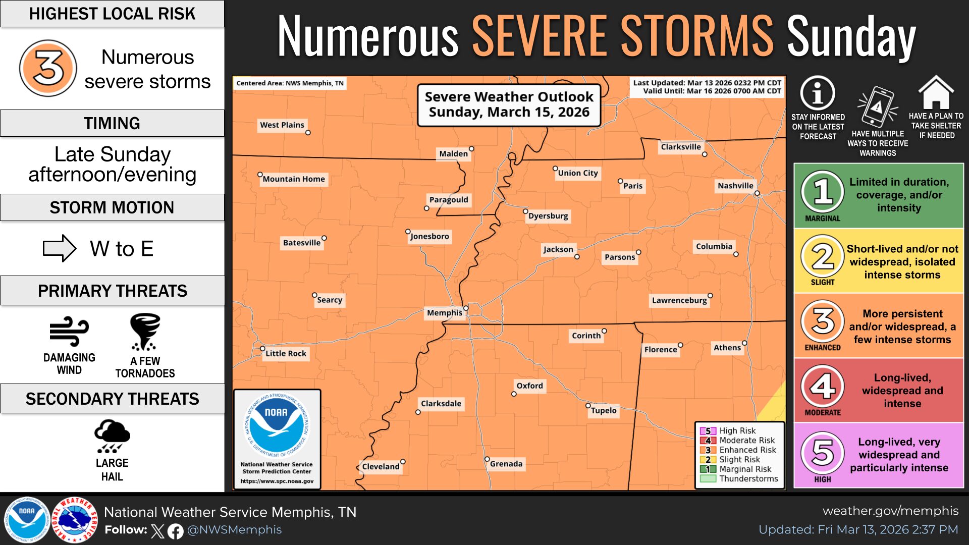
Jonesboro, AR – JonesboroRightNow.com – Jonesboro and parts of Northeast Arkansas are under an enhanced risk for severe weather Sunday.
According to the National Weather Service (NWS), a cold front will move through the area Sunday afternoon and evening, increasing the risk of severe weather. The NWS said there is a line of storms that moves quickly from west to east.
| WEATHER UPDATES: Click here for seven-day and hour-by-hour Jonesboro weather forecasts
The primary threat will be damaging winds, which the NWS said could be “significant” and exceed 75 mph. Ahead of the cold front, non-thunderstorm winds will be elevated, with intermittent south wind gusts up to 40 mph. Ahead of the storm, secure any items that are sensitive to gusty winds.
The NWS added that embedded, quick spin-up tornadoes will be a concern.
Heading into next week, colder air will follow this front. Subfreezing temperatures are forecasted early next week, with a widespread freeze expected Tuesday morning. There is a potential for some snow flurries Sunday night, but nothing impactful, according to the NWS.
Things to do right now:
- Make sure you have emergency supplies, just in case
- Know your safe place, and make sure your entire family knows
- Have a way to communicate urgent information to your family
- Make sure you have a way to receive emergency alerts on your phone
Be prepared to receive severe weather warnings and information. Jonesboro Media Group radio stations 104.9 The Fox, 100.5 The Eagle, and Mix 106.3 will broadcast severe weather information. Live-streaming options for all three stations are below:
- Click here to listen to 104.9 The Fox.
- Click here to listen to 100.5 The Eagle.
- Click here to listen to Mix 106.3.
The Region 8 Storm Team (KAIT-TV) will also provide severe weather coverage. Warnings and information are also available on NOAA Weather Radio, broadcast in this area on 162.55 MHz.
Jonesboro forecast:
- Friday: Sunny, with a high near 66°F. Southwest wind 10 to 15 mph.
- Friday Night: Mostly clear, with a low around 45°F. South wind around five mph, becoming east-southeast after midnight.
- Saturday: Sunny, with a high near 71°F. South wind five to 10 mph.
- Saturday Night: Partly cloudy, with a low around 57°F. South wind 10 to 15 mph.
- Sunday: Showers likely and possibly a thunderstorm, mainly after 4 p.m. Mostly cloudy, with a high near 74°F. Breezy, with a south wind 15 to 20 mph, with gusts as high as 35 mph. The chance of precipitation is 70%. New rainfall amounts between a tenth and a quarter of an inch, except higher amounts possible in thunderstorms.
- Sunday Night: Rain showers before 1 a.m., then a slight chance of rain and snow showers between 1 a.m. and 4 a.m., then a slight chance of snow showers after 4 a.m. Some thunder is also possible. Low around 30. Blustery, with a south-southwest wind around 20 mph becoming west-northwest after midnight. Winds could gust as high as 35 mph. The chance of precipitation is 80%. New snow accumulation of less than a half inch is possible.
- Monday: Sunny, with a high near 39°F. Breezy, with a west-northwest wind around 20 mph, with gusts as high as 30 mph.
- Monday Night: Mostly clear, with a low around 22°F. Northwest wind five to 15 mph.
- Tuesday: Mostly sunny, with a high near 45°F.
- Tuesday Night: Mostly cloudy, with a low around 36°F.
- Wednesday: Partly sunny, with a high near 62°F.
- Wednesday Night: Partly cloudy, with a low around 47°F.
- Thursday: Mostly sunny, with a high near 73°F.
UPDATE: The severe weather outlook map was updated after the NWS placed an enhanced risk for severe weather across its entire coverage area at 2:44 p.m. Friday, March 13.
| DAILY BRIEF: Sign up for the Jonesboro Right Now Daily Brief Newsletter