UPDATE 7:37 P.M:
The tornado warning for south central Greene County, Craighead County, western Poinsett County, northwestern Mississippi County and northwestern Cross County has been cancelled.
The NWS said the tornado threat had diminished, so the warning was cancelled. However, large hail and damaging winds remain likely, so a severe thunderstorm remains in effect for the area.
The area remains under a tornado watch until midnight.
UPDATE 7:29 P.M.:
Per Jonesboro E-911, Highway 18/135 in Lake City and Monette are completely shut down at the time. Multiple power lines, houses and electric poles are across the roads. Avoid the area.
UPDATE 7:17 P.M.:

UPDATE 7:09 P.M.:
The NWS said spotters have reported a tornado “violent cone” that passed just west of Monette. Caraway residents are advised to seek shelter.
UPDATE 7:03 P.M.:
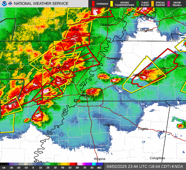
The NWS issued a tornado warning for south central Greene County, Craighead County, western Poinsett County, northwestern Mississippi County and northwestern Cross County.
The warning lasts until 8 p.m.
A severe thunderstorm capable of producing a tornado was located near McFadden, or 14 miles southeast of Newport, moving at 60 mph at 7:02 p.m. The NWS said there is radar-indicated rotation with this storm.
Impacted locations include Jolliff Store, Apt, Delfore, Vail, Valley View, Carmi, Gum Point,
Whisp, Farrville, Lester, Craighead Forest Park, Promised Land, Bethel, Finch, Lorado, Herndon, Needham, Lunsford, Davis Spur, and Pittinger.
UPDATE 6:52 P.M.:
A tornado emergency has been declared for Monette. At 6:50 p.m., a confirmed large and destructive tornado was located over Monette moving northeast at 40 mph.
UPDATE 6:41 P.M.:
A tornado emergency was issued for Lake City. A 6:39 p.m., a confirmed large and destructive tornado was located over Lake City, moving northeast at 40 mph. The NWS said this is a particularly dangerous situation.
UPDATE 6:38 P.M.:
The NWS has issued a tornado warning last until 7:45 p.m. At 6:37 p.m., a “confirmed large and extremely dangerous tornado was located near Bay, moving northeast at 40 mph.
“This is a PARTICULARLY DANGEROUS SITUATION. TAKE COVER NOW!” the NWS said.
According to the NWS, weather spotters confirmed the tornado.
UPDATE 6:34 P.M.:
A tornado warning was issued for Craighead County. It remains in effect until 7:30 p.m.
At 6:34 p.m. a severe thunderstorm capable of producing a tornado was located over Cash, or eight miles southwest of Bono, moving northeast at 50 mph. This is radar-indicated rotation.
Affected locations include: Locations impacted include: Paulding, Apt, Scobeville, New Survey, Valley View, Marmaduke, Gobler, Covington, Farrville, Cardwell, Lester, Mounds, Craighead Forest Park, Halliday, Caruth, Deer Land, Arkmo, West Kennett, Leonard, and White Oak.
UPDATE 6:31 P.M.:
At 6:28 p.m., a confirmed tornado was located over Greenfield, or near Trumann, moving northeast at 45 mph, according to the NWS.
UPDATE 6:26 P.M.:
At 6:24 p.m., a confirmed tornado was located over Greenfield, or eight miles north of Harrisburg, moving northeast at 40 mph, according to the NWS. The warning for northwestern Cross County was cancelled. Quarter-size hail is expected.
Affected locations include Hergett, Tulot, Weona, Hatchie Coon, Gum Point, Maple Grove, Promised Land, Cary, Harrisburg, Judd Hill, Lache Lake, Trumann, Needham, Bunney, Lake Poinsett State Park, Lunsford, Landers, Davis Spur, Elm Grove, and Sandy.
Previously:
Craighead County, AR — (JonesboroRightNow.com) — April 2, 2025 — The National Weather Service placed parts of Craighead County under a tornado warning.
According to the NWS, a tornado warning is in effect for southeastern Craighead County, Poinsett County.
Affected locations include Payneway, Hergett, Wiley Crossing, Tulot, Supply, Marked Tree, Weona Junction, Weona, Hatchie Coon, Gum Point, Stewart, Maple Grove, Lepanto, Fisher, Hickory Ridge, Promised Land, Bay Village, Alto, Cary, and Harrisburg.
“A large, extremely dangerous and potentially deadly tornado is on the ground. To protect your life, TAKE COVER NOW! Move to a storm shelter or an interior room on the lowest floor of a sturdy building. Avoid windows. If you are outdoors, in a mobile home, or in a vehicle, move to the closest substantial shelter and protect yourself from flying debris,” the NWS said.
The warning lasts until 7 p.m. According to the NWS, at 6:08 p.m., a confirmed large and extremely dangerous tornado was located near Waldenburg, or nine miles southwest of Harrisburg, moving northeast at 40 mph.
The NWS added that this is a particularly dangerous situation.
Take shelter now. Move to the lowest level or the most interior part of your home.
Click here for information about public storm shelters.
Listen below for LIVE, round-the-clock coverage of severe storms. JRN will continue to work to provide immediate updates on our news site.
- Click here to listen to 104.9 The Fox.
- Click here to listen to 100.5 The Eagle.
- Click here to listen to Mix 106.3.
A tornado watch went into effect for Craighead County at 2:50 p.m. It remains in effect until midnight.
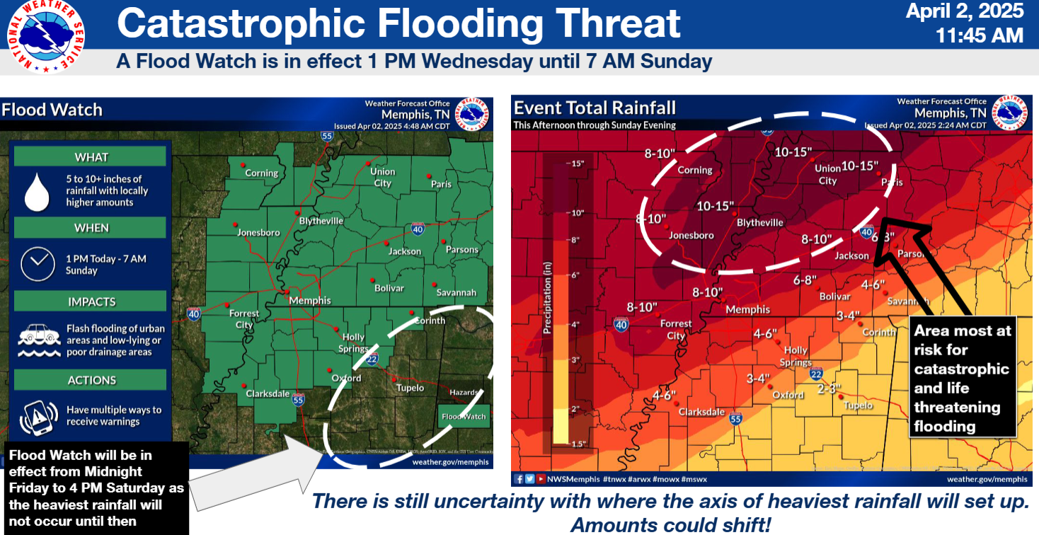
In addition, Craighead County and other Northeast Arkansas counties are under a flood watch. The watch was first issued on April 2 at 1 p.m. and remains in effect until Sunday morning. Affected areas include Jonesboro, Paragould, Wynne, Blytheville and more. Rainfall amounts are forecasted to exceed eight inches, with up to 15 inches possible in some parts of the watch area.
“This is a particularly dangerous situation with generational flooding likely,” the NWS said. “Creeks and streams may rise out of their banks. Extensive street flooding and flooding of creeks and rivers are possible.”
Do not try to walk in flooded areas. Do not attempt to cross flooded areas with your vehicle. Turn around, don’t drown.